-
 play_arrow
Mix96
-
 play_arrow
Demo Radio Channel Top Music Radio
-
 play_arrow
The Final 2026 Primary Election Gubernatorial Forum


LIVE UPDATE: Stay up to date with MIX 96 Storm Updates!

STAY UP TO DATE WITH OUR STORM UPDATES ON PODCAST GUAM: HERE
Guam is in COR 1, with everyone advised to stay safe and shelter in place. Stay off the roads, and out of the water.
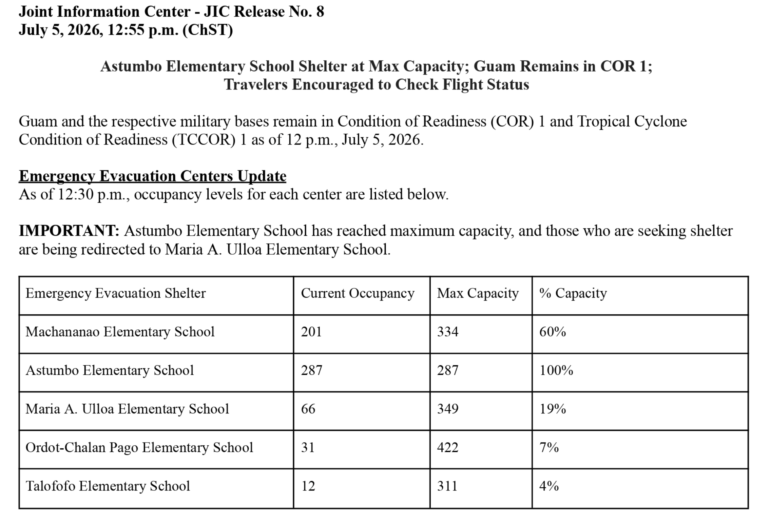
Shelters have opened and here is the latest:
National Weather Service Tiyan GU
1205 PM ChST Sun Jul 5 2026
A Tropical Storm Warning has been issued for Alamagan.
A Coastal Flood Warning is now in effect for Guam, Rota, Tinian,
and Saipan.
A High Surf Warning is now in effect for Guam, Rota, Tinian and
Saipan.
A Typhoon Warning continues for Guam, Rota, Tinian, and Saipan,
and surrounding coastal waters.
A Flood Watch is in effect for all of Guam and the Northern
Marianas. Please listen closely for any Flood Warnings that might
be in effect for your area.
A Tropical Storm Watch continues for Pagan and Agrihan.
Please check the latest public and marine forecasts for detailed
information about additional hazards.
.STORM INFORMATION…
At 8 AM ChST, the center of Super Typhoon Bavi (09W) was located
near latitude 12.9N, longitude 149.2E. This was about 300 miles
east of Guam. Storm motion was west, 280 degrees, at 7 mph. Storm
Intensity was 155 mph.
.SITUATION OVERVIEW…
A Typhoon Warning remains in effect for the Marianas. Super
Typhoon Bavi (09W) is expected to make passage through the
or Category 5 strength. It is expected to make a turn toward the
Monday. The onset of tropical storm force conditions is currently
expected late this afternoon or evening. The latest forecast
track still maintains passage somewhere near or to the north of
Rota Island, but there is time for the track to shift north or
south. All islands will experience impacts. At minimum, damaging
tropical storm force conditions are expected, but damage will be
catastrophic near the center of Super Typhoon Bavi, with maximum
sustained winds forecast at 160 mph at time of passage.
Significant flooding from torrential rains, and coastal inundation
are expected. Surf will become extremely dangerous ahead of
Bavi`s approach, potentially reaching 35 feet Monday. Significant
coastal inundation and erosion are expected, with inundation
heights reaching up to 12 feet especially near the storm center.
For the islands closest to passage of Super Typhoon Bavi, the
onset of typhoon conditions is expected early Monday morning just
ahead of Bavi`s center, continuing through Monday afternoon. The
latest forecast from the Joint Typhoon Warning Center (JTWC)
suggests that destructive typhoon conditions may be expected for 8
to 10 hours close to the center`s passage depending on forward
speed.
.PRECAUTIONARY/PREPAREDNESS ACTIONS…
For those under a Warning, preparations should be complete for
the protection of life and property. The window to evacuate or
seek shelter is closing, as damaging tropical storm conditions
are expected to develop late this afternoon or evening. Evacuate
if directed to do so by local officials, or if your home is
vulnerable to high winds or flooding.
For interests at ports, docks, and marinas, it is recommended
that you perform the prescribed preparations according to your
emergency operations plan for tropical cyclones. Secure all
vessels. If you live on a boat, immediately and safely secure
your craft and make plans to leave it for adequate land based
shelter. Conditions are expected to be catastropic for small
craft, and extremely dangerous for any vessels of larger size.
Stay indoors during heavy rain and windy conditions from Super
Typhoon Bavi. The onset of damaging, and potentially destructive
winds, will pose a deadly threat to those venturing outside.
Closely monitor NOAA weather radio or other local news outlets for
official storm information. Listen for possible changes to the
forecast.
For additional precautionary and preparedness information, please
refer to the detailed recommendations relative to your location
as further described by your local National Weather Service office
and your local emergency management.
…WIND INFORMATION…
As Super Typhoon Bavi (09W) approaches, sustained tropical storm
force winds are expected to begin late this afternoon. Maximum
winds are forecast to be in the 60 to 80 mph range with gusts to
100 mph. Damaging winds are expected. Poorly constructed metal roof
homes may be destroyed. Some well constructed metal roof homes will
have substantial damage and could become uninhabitable. Some homes of
frame construction will sustain partial wall and roof failure, and
possibly blown out windows. Loose outdoor items will become
projectiles, causing additional damage and possible injury. Many areas
will experience power outages with some downed power poles. Numerous
large branches of healthy trees will snap. Some trees will be
uprooted, especially where the ground is saturated.
…COASTAL INUNDATION AND SURF INFORMATION…
Coastal inundation heights could reach 3 to 5 feet. Additionally,
surf of 10 to 15 feet this afternoon could build to between 15
and 25 feet as Bavi passes to the north Monday morning.
…OTHER STORM EFFECTS…
A Flood Watch is in effect for the entire area. See latest
forecast for latest information. Listen for possible flood
warnings for your location…and be ready to act if flooding
rains occur.
There could be accumulations of 12 to 16 inches of rainfall through
Tuesday.


Now on air